NASA Is Building The First GPS For The Moon
One of the major hurdles while landing on the moon is navigation. If the spacecraft’s velocity is off slightly, the spaceship might crash on the moon’s far side. This seems to be the main concern for NASA right now and according to a new report NASA is building the first GPS for the moon landing.
More than 50 years later, while considering NASA’s upcoming Artemis missions to the moon, the agency is again thinking of navigation and safety issues. Hence, NASA wants to test a novel lunar navigation system capable of using signals from the Earth’s Global Navigation Satellite System (GNSS) in the moon’s vicinity.
Although there is no prior evidence of its execution, NASA is willing to send the experimental payload to the moon. The responsibility of the tentative lading is being handed to Firefly Aerospace’s Blue Ghost lander till 2024, as per NASA.
The New Project
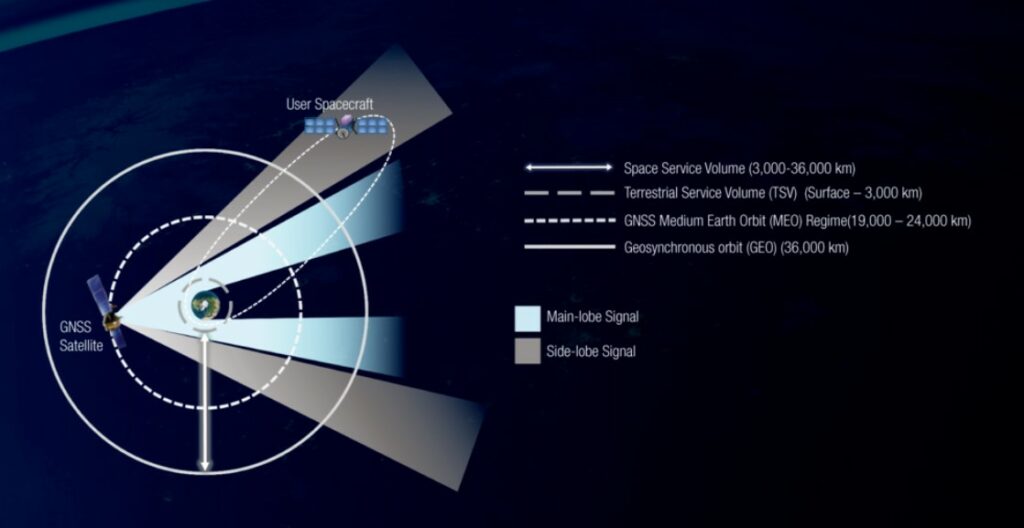
The GNSS denotes the satellite assemblages that convey the timing, positioning, and navigation signals from space to receivers located on earth. The most popular GNSS system that we often opt for is GPS which the U.S. Space Force operates.
NASA’s Lunar GNSS Receiver Experiment (LuGRE) is established in close partnership with the Italian Space Agency (ASI). It will be the first to calculate the locate fixes during the trip to the moon along with the lunar surface.
It will receive signals from Europe’s GNSS constellation (Galileo) and GPS. It will also allow the receiver to conduct various navigation experiments at multiple altitudes while orbiting around the moon.
After landing, Blue Ghost (LuGRE receiver) will open its antenna and gather data for up to 12 days or more. It will be sent back to earth and used to create the operational lunar GNSS system for future missions.
“In this case, we are pushing the envelope of what GNSS was intended to do—that is, expanding the reach of systems built to provide services to terrestrial, aviation, and maritime users to also include the fast-growing space sector,” said J.J. Miller, Deputy Director of NASA’s Space Communication (SCan) program.
He further states “This will vastly improve the precision and resilience of what was available during the Apollo missions, and allow for more flexible equipage and operational scenarios.”
LuGRE is an effort to increase the high-altitude capacity of GNSS. Recently in the past few years, the reach of the system of expanded to 2,896 kilometers (1,800 miles) and 35,405 km (22,000 miles) in altitude. In 2016, NASA’s Magnetospheric Multiscale Mission used GPS at a record altitude of 70,000 KM above the earth, and now they want to increase it further.